Saturday, May 24, 2014

Prairie View

Day Hike
Distance: 5km (Up)
Height gain: 500m
High point: 1875m
Time: 4-5 hours
Difficulty: Moderate

Access:
Take Trans-Canada Highway out to Canmore. Take the turn off onto Kananaskis Trail (Hwy 40). Then at the Barrier Dam day use area.

Experience:
This was a really nice hike! Its about 7km to where we stopped which is by a large metal plate. The weather was perfect because it was cloudy with a bit of sun. For most of the hike it was just my Mom, Gabi, and I and it was really fun to walk and talk with them. If I was to rate this hike it would be about a medium hike for my skill level. Even though it was easier than last week's hike it still made me sweat and I will be a bit sore tomorrow. Surprisingly I'm not too tired, it was definitely a nice day hike to take some friends on. There were steep parts and flat parts, and the view was very rewarding. Nothing really interesting happened other than the cute chipmunks stealing Gabi's bread haha. My 3 older brothers also came along (Jesse, Robert, and Devon) but they went ahead by themselves to leave the snails in the back. On the way back we were debating about if we should go into the water but our feet were starting to hurt so we just wanted to get home. All in all it was wonderful to get out into the woods and seeing some wild flowers with pretty amazing people.
Barrier Lake from the parking lot

My hiking buddies

Selfie!

Almost at the top!


What is this? I dont know but this is the top!
Some wild flowers! The first ones I have seen since the winter has finished

The Prairie View

Gabi and I at the top with Baldy Mount behind us

A view of Barrier lake

To the right is Heart Mount, but this is the view that was to our right

Mom and I <3

Monday, May 19, 2014

Ha Ling's Peak (Chinaman's Peak)

Day Hike
Distance: 1.6km (Up)
Height gain: 732m
High point: 2408m
Time: 3-4 hours
Difficulty: Hard

Access:
Go to Canmore and follow signs to Smith-Dorrien Spray Trail (Hwy 742). Then go up the hill and then park in the Goat Creek parking lot.

Story:
For this mountain there is a little story on how it got its name. Originally the mountain was called 'The Beehive' Then in 1896, Ha Ling, a Chinese cook working in the Oskaloosa Hotel in Canmore, was bet $50 he couldn't climb up and down the mountain in 10 hours. Starting at 7 on a Saturday morning with a small flag to place on the summit, he was back in time for lunch. No one believed he did it that fast because they couldn't see the flag. So on Sunday Ha Ling led a group of doubters to the top and next to the original flag proudly flapping in the wind set up a 12 foot high flag pole with a scarlet six foot square flag that could be seen with the naked eye from Canmore. They then decided to call the mountain Ha Ling's Peak, but it is more renown for the name Chinaman's Peak.

Experience:
 From my experience, if I was to describe this hike in one word it would be Torture. 
At first we were pumped to get going on my first hard hike of the season. As we climbed I was getting tired fast! After the first 30min I felt I was ready to go back down haha. It was kinda steep and it was snowy and wet. Nonetheless we took pictures and continued up the mountain. Once I got past the first bit I was feeling okay, and I didn't feel as out of breath. Anyways we trekked through the trees and saw some chipmunks yapping at each other just like Arthur and the pink squirrel from The Sword in the Stone by Disney. It was SOOO Cute! After that that's when we hit the snow which was deep, slippery, and cold and that's when it started to get really really really HARD! We came out of the tree line and stared at the challenge in front of us. Loose gravel and more slippery snow. Yay.
 I was already tired but we were determined to get to the top. We slowly made our way up. My legs and ankles were dying and every time I looked back I could see how steep the way down was and if I slipped and fell the wrong way I would mostly likely die. At least that is what I thought at the time. 
We were so high up! and we weren't even at the top yet! About 1/3 of the way up the steep loose gravel path I was taking 4 steps and resting for 30sec. I was barely moving. Mom was with me and it wasnt helping that she was saying she wanted to stop, or that she wanted not to go any higher BUT I pushed through her suggestions and walked like a snail up the gravel. 
Once I was about 50 feet from the tippy top, which seemed so far away, I broke down because I could see over the edge and actually believed I was going to die. Seems irrational I know but that is what I believed. My mom stopped about then and I decided to make it to the top with Dad so I did!
Once I got up close to the edge I was freaking out a bit because I am quite afraid of heights. While I was up there I was questioning myself why am I going on hikes when I'm terrified of heights? I dont know why but I believe I can do hard things and being up high is very hard got my head to wrap around. I calmed myself and then I felt like I was a very important person to be so much higher than very body else haha. I could see everything around me, there was nothing blocking my view . It was so good! 
After a few minutes I wanted to get down because every possible path I could take was either straight down hill or really steep. So we left and made our way down and it started to rain. Everything was just going down hill for me (pun intended). 
Because we were so high up we could see the easy path down so we took it, but that path soon turned into a very difficult path because the snow started again and it was up to our waist! We trudged through it and because I was already SOOOOOO EXHAUSTED and the snow took soo much effort to walk through it I just couldnt hold it in anymore and I started crying because my legs, butt, and hands were frozen. Also I got stuck in the snow and my Dad had to come back and pull me out. It was really traumatic at the time for me.
We met up with my mom and headed down together, but the first half we were basically just sliding down in the snow on our butts. It was easier than walking and falling over every 2 steps we took. The downside is that it hurt our butts A LOT! My bum was stinging so bad and once I fell on a rock and I couldn't even feel it because my butt was so cold it was numb. I wish I got a photo of us sliding down the hill but I didn't even think of it at the time. 
Once we got through the icy slushy snow we were fine and cruised down the rest of the mountain while passing a few groups of people which rarely happens when I hike with my mom. We made it down and my body was covered in pins and needles and my muscles felt like jello. We got in the van and went home.
I might never want to do that hike again but I'm glad I got to the top and didn't die afterall. 
If I was to do it differently I would have brought a crazy carpet to slide down the mountain on :P
 At the parking lot

The man made canal on the bottom

The sign for the start of the hike

What it says


The stream by the path

The tiny waterfall


Mom and I at the start of the snow


Its getting hard!


When the path was nice.

Mom and Dad. 

The yappy squirrel 


The snow and the loose gravel :(


We were sweating buckets

This is proof I made it to the top!

The scary edge. You can see a bit of Canmore

Canmore Side. North view

East view

South View

South West View

West View

The party who made it to the top

I did it!

Time to go down. :(

Saturday, May 10, 2014

Hogarth Lakes?


 Okay. Today was just weird. I wanted to go French Creek so we went on our adventure determined to get to at least the first waterfall even through the snow. As Robert and I drove we just kept on going and going and going and going. We ended missing our turn off and going all the way up to the Kanasakis Lakes which is where we didnt want to be. We wanted to be at French Creek!
As we drove we were not disappointed though because the mountains and trees looked so majestic especially with the light fog. It was quite rewarding to drive through the K Country. The roads were emitting steam and that was kinda cool to drive in.
 Anyways.
If you want to know how to get to French Creek, go on smith dorrien spray trail in the Peter Lougheed Zone. Follow the road till you see signs for Burstall and Chester Lake. Just follow the signs for Burstall pass. Park your car and then you'll see....................
..............................................................................
..............................................................................
..............................................................................
..............................................................................
.............................................................................
.............................................................................
 ..............................................................................
..............................................................................
..............................................................................
..............................................................................
..............................................................................
..............................................................................
..............................................................................
.............................................................................
............................................................................
..............................................................................
..............................................................................
..............................................................................
Mount Burstall
 ...............................................This to your right!
--------------------------------------->
This is Mount Burstall everyone! It was rewarding to see because we were driving for 2 1/2 hours just to find this place.
This place had SOOO MUCH SNOW! It was crazy! We couldnt find any path except some cross country ski trail that a random person blazed, and a old path of tracks that could have been animal tracks going around the lake. It was good that we went on the high road and followed the animal tracks because the big white field was really Mud Lake and the way we could only tell it was the lake was by a little hole of water on near
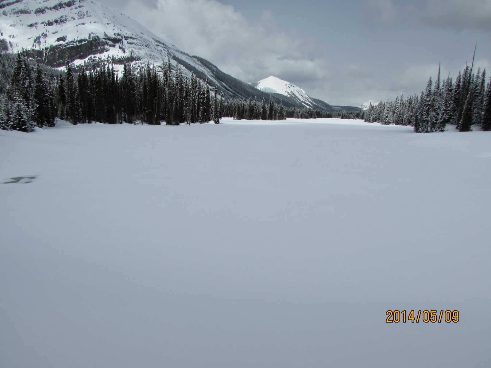
Mud Lake
the edge of the lake. Even though there was a ton of snow it was actually warm and that was nice.
As we walked hoping to find French Creek we came up to the sign "Spray Valley" or in other words Hogarth Lake Loop. We were frustrated and just wanted to start hiking to something that we decided to hike this trail even though it said it was only a snowshoe hike.
We hiked about 10mins and we were already starting to get tired because the snow was coming up to our knees. Then all of a sudden I fell deep into the snow. The snow came up to butt and honestly think the only reason why I didnt fall
 deeper was because my other leg was in the way.
Once I got out i took a picture because I stepped on a tree! I dont know how tall the tree was but all I know is that I stepped on a tree that was completely cover in snow! So now my right leg was covered in snow and because it was warm it melted fast on me and I was nice and wet. After that I decided that this had to be good enough for this weekend because there was way to much snow and I was already soaking wet.

 Just to make my day so much better my left leg decided to take a step into the deep snow and this time i had Robert take a photo of just how deep my left leg was in the snow. It was kinda funny honestly, and I did not regret my choice to head back because now both of my legs are soaked all the way up to my butt. Yup, it was great Hah!
So we got to the car and headed home! Yay! We barely hiked but whatever I guess. Its not my fault the snow isnt melting and is super deep. How can a person hike when every step is at least coming up to their knee and sometimes their butt? Its hard and I'm not doing it and thats final.


Not sure which mountain is in the background but I think it is Mount Gusty

Mount Murray

Mount Cegnfs

Deer

We took the back roads and got to see all of the sides of the very majestic Chinaman's Peak
 Anyways. That was our adventure! We saw all of the Peter Lougheed Area! and almost ran out of gas! Hopefully next week the snow will melt a bit so we can go to Old Goat Glacier! Maybe.... I dont know anymore. But I will do something!